Monieux
Monieux | ||
|---|---|---|
 |
| |
Region | Provence-Alpes-Côte d’Azur | |
Département | Vaucluse | |
Arrondissement | Carpentras | |
Kanton | Pernes-les-Fontaines | |
Gemeindeverband | Ventoux Sud | |
Koordinaten | 44° 4′ N, 5° 22′ O44.0680555555565.3597222222222 | |
Höhe | 439–1.022 m | |
| Fläche | 47,12 km2 | |
Einwohner | 344 (1. Januar 2016) | |
Bevölkerungsdichte | 7 Einw./km2 | |
Postleitzahl | 84390 | |
INSEE-Code | 84079 | |
Website | http://www.ot-monieux.com | |
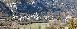
 Blick auf Monieux | ||
Monieux ist eine französische Gemeinde mit 344 Einwohnern (Stand 1. Januar 2016) im Département Vaucluse in der Region Provence-Alpes-Côte d’Azur.
In Monieux wurden zwei Weiheinschriften für den gallo-römischen Lokalgott Mars Nabelcus aufgefunden.
Geografie |
Monieux liegt am Fuße des Bergmassivs, zu dem auch der Mont Ventoux gehört, in der Hochebene von Sault, dem Plateau d’Albion. Hier beginnen die Gorges de la Nesque, die sich das Flüsschen Nesque bis 400 Meter tief ins Gebirge gegraben hat. Die Straße D942 von Villes-sur-Auzon nach Sault führt durch die Schlucht und durch Monieux.
Einwohnerentwicklung |
- 1962: 139
- 1968: 152
- 1975: 122
- 1982: 171
- 1990: 158
- 1999: 250
- 2008: 344
Weblinks |
.mw-parser-output div.BoxenVerschmelzen{border:1px solid #AAAAAA;clear:both;font-size:95%;margin-top:1.5em;padding-top:2px}.mw-parser-output div.BoxenVerschmelzen div.NavFrame{border:none;font-size:100%;margin:0;padding-top:0}
.mw-parser-output div.NavFrame{border:1px solid #A2A9B1;clear:both;font-size:95%;margin-top:1.5em;min-height:0;padding:2px;text-align:center}.mw-parser-output div.NavPic{float:left;padding:2px}.mw-parser-output div.NavHead{background-color:#EAECF0;font-weight:bold}.mw-parser-output div.NavFrame:after{clear:both;content:"";display:block}.mw-parser-output div.NavFrame+div.NavFrame,.mw-parser-output div.NavFrame+link+div.NavFrame{margin-top:-1px}.mw-parser-output .NavToggle{float:right;font-size:x-small}
